

FEATURED HISTORICAL PHILIPPINE MAPS
From the body of many important antique printed maps, below we have chosen just a few extraordinary ones to wet your appetite. A few hundred more preserved old maps and books of different islands of the archipelago can be found at the
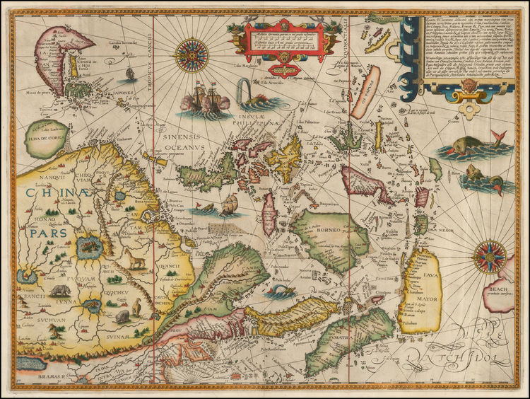
Linschoten, India Orientalis
…
by Jan Huygen van Linschoten
Map from the “Itinerario. Voyage ofte Schipvaert”,
published in Amsterdam/Netherlands , ca. 39 x 52 cm.
This striking and important map of the East Indies or India Orientalis was based upon Portuguese gleaned sources by van Linschoten during his residence in Goa and from his close association with the Dutch cartographer & orientalist Petrus Plancius. The map is oriented with North to the left. This is the map which Kaerius used to produce the first map to show the Philippine Archipelago alone on one single sheet ; he sort of just cut out the Philippine part!
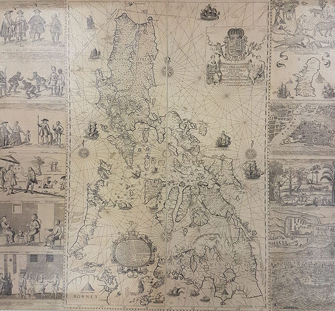
Carta Hydrographica y Chorographica delas Yslas Filipinas Dedicada al Rey Nuestro Señor Por el Mariscal d Campo D. Fernando Valdes Tamon – 1734
by Francisco Suarez,
engraved by Nicolás de la Cruz Bagay,
published by Fr. Pedro Murillo Velarde, Manila, ca. 112 x 120 cm.
This is the most famous of all maps of the Philippines with vignettes on each side depicting different ethnic groups living in the Philippines, rural scenes, domestic and wild animals, and four maps of Cavite, Manila, Zamboanga and Guam. It became the standard for Western maps of the Philippines virtually for the rest of the 18th Century.
Murillo, Carta Hydrographica
…
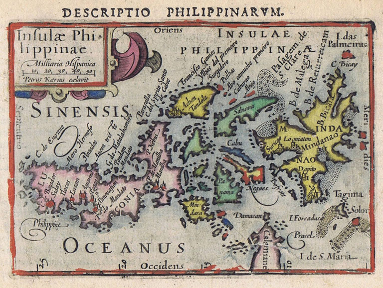
Kaerius, Insulae Philippinae
…
Not until 1595 was the first map finally drawn showing the Philippines in its own singularity-
by Peter van den Keere (Petrus Kaerius), a remarkable Dutch cartographer.
In 1598 it was published for the first time in the Caert Thresoor (Treasury of Charts) – a pocket atlas for ‘citizens with the lowest income’ by an equally noted Dutchman, Barent Langenes.
Featured is the Latin edition, first published in the same year.
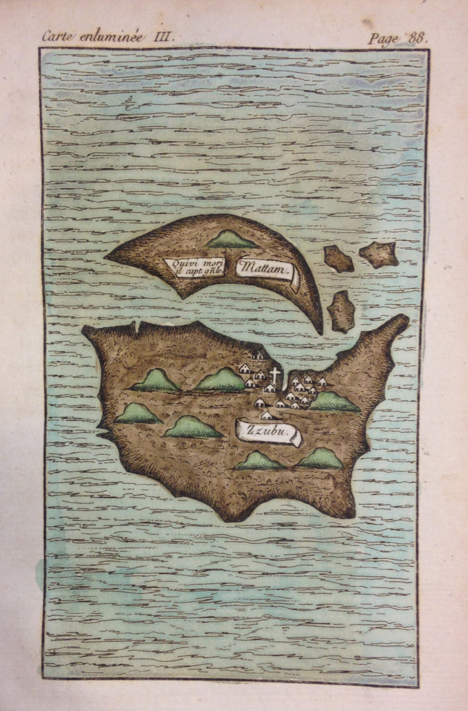
For centuries, contacts had existed between our Islands, later called the Philippines, and the Asian continent before the archipelago was discovered for the Western World by Ferdinand Magellan in 1521. He paid for it with his life, killed by the local Chieftain Lapu-Lapu in battle on the coastline of Mactan Island, adjacent to Cebu Island in the Philippines – here depicted by Antonio Pigafetta (ca. 1491-1531) in the first printed account published in 1801, based on the surviving manuscript. The first circumnavigation was completed by Juan Sebastián Elcano.
Pigafetta, L’íle de Zubu, et la petite ile de Matan
…
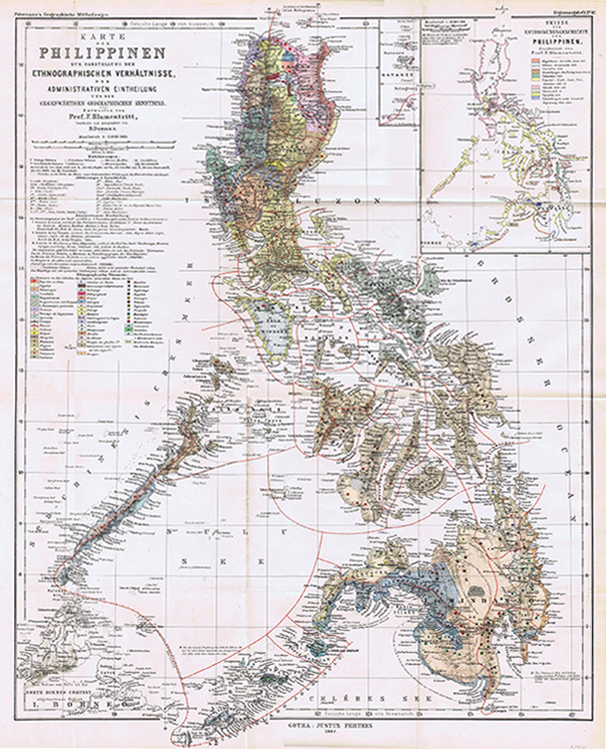
Blumentritt, Karte der Philippinen
…
Map of the Philippines “Karte der Philippinen” – 1882
by Ferdinand Blumentritt (1853 -1913)
Original-colour lithograph, ca. 55 x 42 cm.
Blumentritt of Litmerice in Bohemia (then Leitmeritz in the Austro-Hungarian Empire) was a close friend of the Philippine National Hero, Dr. Jose Rizal, This is the most important map of several maps of the Philippines that Blumentritt created and which were published in various German and Austrian scientific publications together with articles on the featured topics, a fact which made him the recognized specialist on matters concerning the Philippines in his time.